A Recently Discovered Long Barrow near Southbourne, West Sussex

Michael Gill, May 2026

The Neolithic long barrows of the chalk downs of Sussex have long been the subject of detailed study (Toms 1922; Curwen & Curwen 1925; Grinsell 1930, 1934). Earlier studies tended to concentrate on the monuments with upstanding earthworks, and these were complemented with further examples revealed from cropmarks on aerial photographs (Carpenter et al. 2026: fig. 13; 155), or from geophysical survey in advance of development (Lefort 2012). Given such a long tradition of study, it might be thought that most of these relatively rare monuments have been discovered, with any missing examples irrevocably lost through modern development. However, the explosion of publicly available satellite and aerial imagery during the last twenty years has provided a set of data that, with careful review, can add further examples which might only be briefly revealed under perfect crop and meteorological conditions. Such is the case with an example recently discovered by the author in the parish of Southbourne, West Sussex, close to the border with Hampshire. This apparent long barrow is a substantial 80m in length and given the clarity of the cropmarks, it is amazing it has escaped detection for so long.

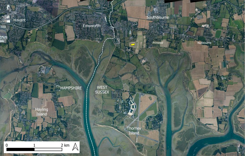
Figure 1: Location of the recently discovered long barrow in the parish of Southbourne (indicated with a yellow symbol). Contains public sector information licensed under the Open Government Licence v3.0.

This long barrow is located just north of Thorney Island, one kilometre south-east of Emsworth (Hampshire) and 500 metres west of the hamlet of Prinsted (West Sussex), as shown in Figure 1. It is centrally positioned on a narrow neck of land between the heads of two of the numerous marine inlets that characterise the coastline in this part of southern England.

Continue reading “A Recently Discovered Long Barrow near Southbourne, West Sussex”

A Recently Discovered Long Barrow near East Meon, Hampshire

by Michael Gill

Neolithic long barrows are amongst the earliest monuments in Britain and are relatively rare compared to the almost ubiquitous Bronze Age round barrow. Despite their rarity, the volume and frequency of new releases of aerial and satellite imagery on publicly available websites means that new discoveries of long barrows are sometimes made. This is the case with an example near East Meon, in Hampshire, where the cropmarks of a long barrow have recently been identified by the author. This article will describe the characteristics of the long barrow and its landscape position.

The location of the long barrow is shown in Figure 1. It is positioned on a gentle west facing slope, adjacent to the springs that represent the source of the River Meon. It is about 1.3 km south of the village of East Meon.

Figure 1: Map showing the location of the recently discovered long barrow, shown with a yellow symbol, near the source of the River Meon. The location of the nearby Salt Hill long barrow is shown with a white symbol. Contains public sector information licensed under the Open Government Licence v3.0.

Continue reading “A Recently Discovered Long Barrow near East Meon, Hampshire”

Three Possible Unrecognised Long Barrows near Preston Candover, Hampshire

by Michael Gill

This article can be accessed / cited here: https://doi.org/10.5281/zenodo.19005909 and is available for download as a PDF at the end of this article.

The Candover Valley, a few kilometres south of Basingstoke, has long been recognised for its prehistoric remains and potential for further discoveries (Shore 1893). At Preston Candover, this is attested by the presence of a much denuded Neolithic long barrow (RCHME 1979: 14–15), numerous ring ditch cropmarks and a significant scatter of flint artefacts at Budd’s Hill (Williams-Freeman: 357–58). This article discusses three possible unrecorded long barrows located close to the latter site, revealed through analysis of publicly available aerial imagery.

Continue reading “Three Possible Unrecognised Long Barrows near Preston Candover, Hampshire”

An Unrecognised Long Barrow near Whitsbury, Hampshire?

by Michael Gill

The rolling chalkland of Cranborne Chase has a rich variety of Neolithic monuments, including a dense concentration of long barrows clustering near the Dorset Cursus. This region has long attracted the attention of antiquaries and archaeologists, and as a result is one of the most closely studied prehistoric landscapes in Britain. Consequently, it could be assumed that the most significant Neolithic monuments have already been located and studied. This, however, is far from the truth, with, for example, a number of long barrows and a long enclosure being revealed by aerial imagery and geophysical survey in recent years (Gill 2018, 2023; Gill & Field 2019). One of these long barrows has been shown to be an amazing 112 metres long, and despite being ploughed out, still possesses a spread mound of considerable bulk. The intensification of farming on the downs of Cranborne Chase inevitably led to the destruction of many earthwork monuments, and a careful review of historic maps, LiDAR, and aerial imagery can still lead to new discoveries. This is the case with a probable long barrow at Whitsbury, the mound of which was destroyed in the 19th Century. Since then, it has been hiding in plain sight, potentially being mis-interpreted and recorded as the site of a round barrow.

Continue reading “An Unrecognised Long Barrow near Whitsbury, Hampshire?”

An Unrecorded Long Barrow near Morestead, Hampshire

Cropmarks showing an unrecorded long barrow at Morestead Hampshire

by Michael Gill

This article can be accessed / cited here: https://doi.org/10.5281/zenodo.17265581 and is available for download as a PDF at the end of this article.

Even though Neolithic long barrows are relatively rare, particularly in comparison to Bronze Age round barrows, new discoveries are on occasion made. It is often a specific combination of weather conditions and type of crop that can lead to clear cropmarks appearing for a short period of time, and this was the situation in 2025, when distinct cropmarks over wide areas were revealed in satellite imagery. Such cropmarks in the parish of Owlesbury near Winchester revealed a previously unrecorded long barrow, just 300m from another long barrow.

The cropmarks of this unrecorded long barrow are 1.2km east south-east of Morestead, a village about 5km south-east of Winchester in Hampshire. The cropmarks (Figure 1), which I spotted recently on Google Earth, clearly show the characteristic flanking ditches of a long barrow, which run almost parallel but taper slightly, with the wider end towards the south-east.

Continue reading “An Unrecorded Long Barrow near Morestead, Hampshire”

Unrecognised as the longest long barrow in Hampshire? The Warren Farm long barrow at Morestead

by Michael Gill

This article can be accessed / cited here: https://doi.org/10.5281/zenodo.16921973 and is available for download as a PDF at the end of this article.

Although long barrow discoveries are still being made, it is fair to say that the most substantial examples have probably already been recorded. It is also the case, however, that existing monuments can sometimes pass under the radar, evading detailed study and being unrecognised for their true importance. This could be the case for the Warren Farm long barrow at Morestead, 5km south-east of Winchester, which is recorded as a fairly standard monument, 60m in length. Incredibly, recent evidence from LiDAR and aerial imagery suggests that this long barrow may be over twice its recorded length, perhaps a massive 135m, making one of the longest long barrows in southern England.

Continue reading “Unrecognised as the longest long barrow in Hampshire? The Warren Farm long barrow at Morestead”