
This article can be accessed / cited here: https://doi.org/10.5281/zenodo.20090746 and is available for download as a PDF at the end of this article.
Michael Gill, May 2026
The Neolithic long barrows of the chalk downs of Sussex have long been the subject of detailed study (Toms 1922; Curwen & Curwen 1925; Grinsell 1930, 1934). Earlier studies tended to concentrate on the monuments with upstanding earthworks, and these were complemented with further examples revealed from cropmarks on aerial photographs (Carpenter et al. 2026: fig. 13; 155), or from geophysical survey in advance of development (Lefort 2012). Given such a long tradition of study, it might be thought that most of these relatively rare monuments have been discovered, with any missing examples irrevocably lost through modern development. However, the explosion of publicly available satellite and aerial imagery during the last twenty years has provided a set of data that, with careful review, can add further examples which might only be briefly revealed under perfect crop and meteorological conditions. Such is the case with an example recently discovered by the author in the parish of Southbourne, West Sussex, close to the border with Hampshire. This apparent long barrow is a substantial 80m in length and given the clarity of the cropmarks, it is amazing it has escaped detection for so long.
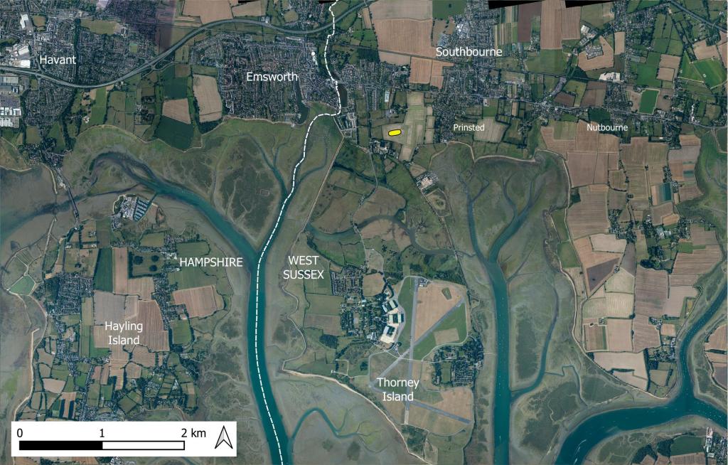
Figure 1: Location of the recently discovered long barrow in the parish of Southbourne (indicated with a yellow symbol). Contains public sector information licensed under the Open Government Licence v3.0.
This long barrow is located just north of Thorney Island, one kilometre south-east of Emsworth (Hampshire) and 500 metres west of the hamlet of Prinsted (West Sussex), as shown in Figure 1. It is centrally positioned on a narrow neck of land between the heads of two of the numerous marine inlets that characterise the coastline in this part of southern England.
The cropmarks were first spotted by the author on Google Earth imagery dated 27/04/2022, as shown in Figure 2 and Figure 3. The flanking ditches of this apparent long barrow show as a pair of clear near-parallel linear cropmarks, almost east-west in orientation. The northern ditch is 77 metres in length, and that to the south is about 82 metres. The gap between ditches is a maximum of 17 metres at the east end, narrowing slightly to 13 metres at the west end.
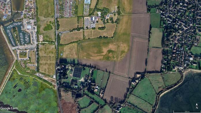
Figure 2: Overview image showing the cropmarks of the long barrow (image centre). Google Earth imagery dated 27/04/2022. ©Google.
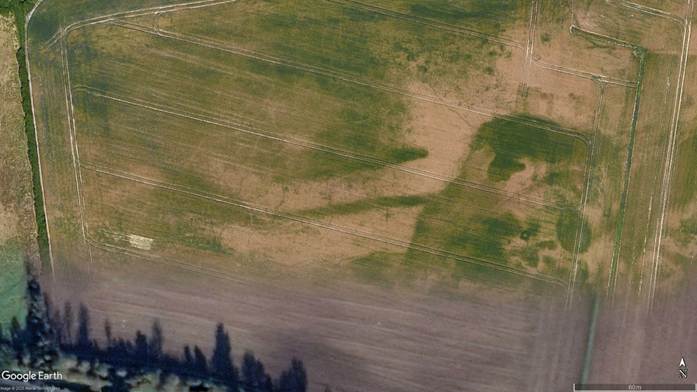
Figure 3: Image showing the cropmarks of the long barrow. Google Earth imagery dated 27/04/2022. ©Google.
When the ditch cropmarks are examined in detail, there is in fact a hint of multiple phases, as shown in Figure 4. To the east the ditch cropmarks are marginally stronger and wider, and slightly arcuate and splayed. To the west of this, the ditches appear to change character slightly, being straighter and slightly weaker. This change in character is marked by a slight change in the direction of each ditch. These characteristics could be interpreted as two phases in the construction of the monument. The first conjectural phase was a long barrow approximately 30 metres in length, with slightly splayed and slightly curving ditches. This appears to have been extended with straighter and longer ditches in a second phase. Similar ‘extensions’ have been noted for other long barrows (Field 2006: 74–75), most notably the bank barrow adjacent to the north-east terminal of the Dorset Cursus (Bradley 1983: 16–17; Gill 2024: fig. 15), but also the long barrow at the opposite terminal of the same cursus (Gill 2024: fig. 30; 18–19).
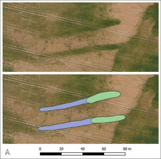
Figure 4: Conjectural phasing as suggested by the shape of the cropmarks of the long barrow ditches. Conjectural phase 1 shown in green, conjectural phase 2 in blue. Google Earth imagery dated 27/04/2022. ©Google.
The cropmarks can in fact be seen, albeit less clearly, in other epochs of imagery, as shown in Figure 5. The Lidar extract in Figure 5 also suggests a subtle linear rise consistent with the cropmarks, indicating the possibility of a very slight remnant mound largely destroyed by ploughing.
The cropmarks of the ditches also show on an RAF post-war aerial photograph dated 19/04/1946, available on the Historic England Aerial Photo Explorer website (https://historicengland.org.uk/images-books/archive/collections/aerial-photos/record/raf_3g_tud_uk_156_v_5051 accessed 19th April 2026), with an extract shown in Figure 6. Although both ditches are visible, they are less clear than in the Google Earth imagery, with what seems to be a gap in one ditch, likely caused by variation in the crop at the time.
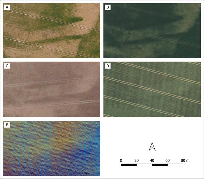
Figure 5: Comparison of different images of the long barrow cropmarks. A: Google Earth imagery dated 27/04/2022 ©Google. B: Esri Wayback Imagery dated 26/06/2019 ©Esri. C: Google Earth imagery dated 23/07/2019 ©Google. D: Google Earth imagery dated 21/04/2007 ©Google. D: Lidar 1m DTM. Contains public sector information licensed under the Open Government Licence v3.0.
It is also notable that the cropmarks of the long barrow ditches were already digitised and recorded as archaeological features by Historic England, available via the Historic England Aerial Mapping Explorer. They have however been interpreted along with other linear cropmarks as field boundaries, as shown in Figure 7.
Turning to the topographic location of the long barrow, Figure 8 shows that it sits centrally on a small area of slightly raised ground which projects into a low-lying area adjacent to the two tidal inlets mentioned above. This would have helped to enhance the visual impact of the barrow, the mound of which was probably elevated in an otherwise flat landscape.
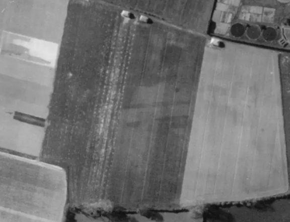
Figure 6: Aerial image from Historic England Archive (RAF Photography). Note – North is towards the bottom of the image. Date flown 19/04/1946. Sortie RAF/3G/TUD/UK/156. https://historicengland.org.uk/images-books/archive/collections/aerial-photos/record/raf_3g_tud_uk_156_v_5051
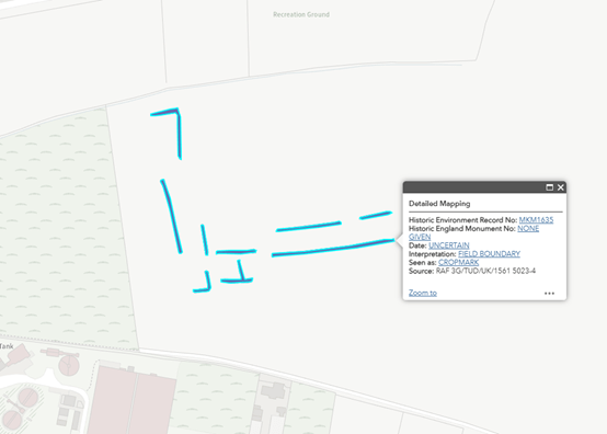
Figure 7: Extract from the Historic England Aerial Archaeology Mapping Explorer. The long barrow ditch cropmarks are recorded with other cropmarks as a group of field boundaries. Accessed 25/04/2026.
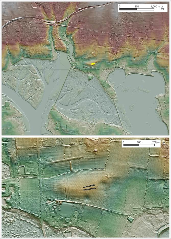
Figure 8: Topographic position of the long barrow, shown on a hillshade of the 1m Lidar DTM. Contains public sector information licensed under the Open Government Licence v3.0.
We can also take a wider view by assessing the position of the barrow in relation to the distribution of long barrows in West Sussex and Hampshire. It is clear in Figure 9 that most of these monuments are concentrated on the band of chalk hills that trend in an east-south-east direction from the upper reaches of the Rivers Meon and Test down into West Sussex, forming the South Downs. There is however a line of long barrows closer to the coast. Two of these barrows were known about at the time of the 1979 RCHME survey of long barrows in Hampshire; the exact location of that near the Naval Telegraph at Portsdown has been lost (RCHME 1979: 72). The other one, Bevis’s Grave at Havant, was excavated between 1974 and 1976 by Rudkin, but an excavation report has never been published (RCHME 1979: 23). A plan, however, of the long barrow ditch revealed in that excavation is published in the RCHME (1979: fig. 34) publication. Both of these barrows sit on top of a thin and prominent ridge of chalk directly north of the series of coastal inlets between Portsmouth and Chichester.
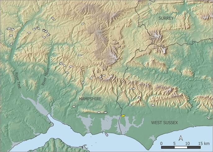
Figure 9: Overview of the location of the Southbourne long barrow (shown in yellow) with respect to the distribution of long barrows in the area. Contains public sector information licensed under the Open Government Licence v3.0.
More recently, a long barrow was recorded near Fareham by a magnetometer survey undertaken by Wessex Archaeology in advance of a housing development, with subsequent excavation (Lefort 2012). This long barrow is due west of, but on the same axis as, the thin chalk ridge described above, as shown in Figure 10. Figure 10 shows that the Southbourne long barrow is due east of this chalk ridge, all four barrows forming a line just north of the coast. There is evidence that prehistoric monuments were sometimes located on significant routes (Bell 2020: 116–17; 163–73); could it be that here the line of barrows fossilises an ancient Neolithic routeway that took advantage of dry ground just north of the low-lying ground surrounding the coastal inlets. Even if not marking a routeway, these sizeable monuments would have formed conspicuous landmarks from both the sea to the south as well as from the relatively flat ground to the north, perhaps acting as territorial markers or helping to reinforce ancestral and kinship ties to the land forming the coastal plain (Edmonds 1997: 107). The discovery of the example at Southbourne is significant as it reinforces the pattern of existing recorded long barrows in this locale.
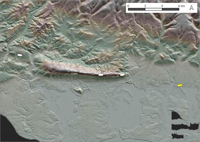
Figure 10: Location of long barrows on or near the coastal plain. The Southbourne long barrow is shown in yellow. Contains public sector information licensed under the Open Government Licence v3.0.
A possible shared connection between these linearly arranged monuments is reinforced by the similarity of their plan, which contrasts with many of the other long barrows in West Sussex. There has long been a perception that long barrows in Sussex are more diminutive in comparison with other regions, such as Wessex (Curwen 1954: 92). Some authors, such as Drewett (1975: 137–38, 1978: 25), even claimed that the shorter long barrows in Sussex, with their more ovate form, were perhaps a separate class of monument later in date compared to larger and more regular examples, and this perception was applied to other regions (for example Bradley et al. 1984: 92; Darvill 2010: 84–85). This assumption has more recently been challenged; some of the dating evidence has been shown to be questionable, and the diversity of form of long barrows demonstrates a continuum from which we should not try to sub-categorise too clinically (Kinnes 1992: 69–70; Russell 2002: 28–29).
In West Sussex, it is certainly the case that most of the known long barrows are of short ovate form. The only example comparable with that at Southbourne is Bevis’s Thumb, Compton, ten kilometres to the north (Drewett et al. 1981: 22–24). However, if we compare the plan of the Southbourne long barrow with the nearby Hampshire long barrows described above, on near the coastal plain at Havant and Fareham, we see more shared characteristics in the form of long regular flanking ditches, as shown in Figure 11. That at Fareham, although shorter in length, has long straight slightly tapering ditches, with a hint of a slight change of direction part way along that could indicate extension in a later phase, just like at Southbourne. For Bevis’s Grave, Havant, we only have a plan of one of the ditches, but this is of similar length to that at Southbourne, and regular in nature. Although the barrow is recorded as completely destroyed, the Lidar shows a slight trace of the mound. Even the now lost long barrow at Portsdown, for which no plan exists, was described as a substantial 73m in length, suggesting a long regular mound rather than a more diminutive mound of ovate form.
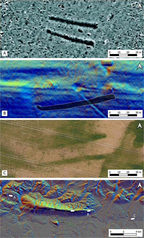
Figure 11: Comparison of the plans of long barrows on or near the coastal plain, all shown at the same scale.. A: Extract of magnetometer survey of a long barrow at Fareham surveyed by Wessex Archaeology (Lefort 2012: fig. 22). B: Bevis’s Grave, Havant. Plan of excavated ditch – after RCHME (1979: fig. 34) – shown on Lidar 1m DTM. C: Google Earth image of the Southbourne long barrow ©Google. Contains public sector information licensed under the Open Government Licence v3.0.
The discovery of a substantial long barrow at Southbourne, so close to the coast, is surprising and significant, given that other long barrows in West Sussex are concentrated on the chalk hills of the South Downs to the north, and that the West Sussex long barrows are generally of short and more ovate form. However, when considering the landscape context of the monument in relation to the nearby Hampshire long barrows, a more coherent picture can be formed, with a series of monuments arranged in a line along the coastal plain, all with similarity in plan and form. These shared characteristics also demonstrate how we should not restrict analysis of long barrows to county studies; in this case connections between Hampshire and Sussex transcend the modern political boundaries often used to frame studies of long barrows.
The burial monuments on the coastal plain would have acted as prominent landscape markers, and we can see from the Lidar that the Southbourne example would have been enhanced by being located on slightly raised ground right next to the coast. Indeed, the clarity of the cropmarks allows us to conjecture a second phase where the long barrow was extended with a ‘tail’, perhaps further enhancing its prominence.
It is clear that long barrows are still being revealed by careful study of the numerous sources of publicly available satellite and aerial imagery, and the coastal plain in Sussex, not considered a typical topographic location for these monuments, may repay much closer inspection in the future.
References
Bell, M. 2020. Making one’s way in the world: the footprints and trackways of prehistoric people. Oxford: Oxbow Books.
Bradley, R. 1983. The bank barrows and related monuments of Dorset in the light of recent fieldwork. Proceedings of the Dorset Natural History & Archaeological Society 105: 15–20.
Bradley, R., R. Cleal, J. Gardiner, M. Green & M. Bowden. 1984. The Neolithic Sequence in Cranborne Chase, in R. Bradley & J. Gardiner (ed.) Neolithic Studies. A Review of Some Current Research (BAR British Series 133).
Carpenter, E., F. Small, K. Truscoe & C. Royall. 2026. South Downs National Park: The High Woods from above NMP. 14–2016 (Research Report Series). Historic England. Accessed May 7. https://www.southdowns.gov.uk/wp-content/uploads/2016/08/TheHighWoodsfromaboveNationalMappingProgramme.pdf.
Curwen, E.C. 1954. The Archaeology of Sussex. Second. London: Methuren.
Curwen, E.C. & E. Curwen. 1925. Two Unrecorded Long Barrows. Sussex Archaeological Collections 66: 172–75.
Darvill, T.C. 2010. Stonehenge: the biography of a landscape. Repr. Stroud: The History Press.
Drewett, P. 1975. The Excavation of an Oval Burial Mound of the Third Millennium bc at Alfriston, East Sussex, 1974. Proceedings of the Prehistoric Society 41: 119–52. https://doi.org/https://doi.org/10.1017/S0079497X0001094X.
—. 1978. Neolithic Sussex, in P. Drewett (ed.) Archaeology in Sussex to AD 1500, 29: 23–29 (CBA Research Report). London: The Council for British Archaeology.
Drewett, P., O. Bedwin & D. Rudling. 1981. Rescue Archaeology in Sussex, 1980: A Seventh Progress Report on the Sussex Archaeological Field Unit. Bulletin of the Institute of Archaeology 18: 21–47.
Edmonds, M.R. 1997. Taskscape, technology and tradition. Analecta Praehistorica Leidensia 29: 99–110.
Field, D. 2006. Earthen long barrows: the earliest monuments in the British isles. Stroud: Tempus.
Gill, M. 2024. Geophysical Surveys of Five Long Barrows near the Dorset Cursus (AVAS Reports AVAS2024-01). Unpublished. https://avonvalleyarchsoc.files.wordpress.com/2024/03/avas-geophysics-surveys-long-barrows-near-dorset-cursus-2023-v1_0.pdf.
Grinsell, L.V. 1930. Long-Barrows and Bell-Barrows in Sussex. Sussex Notes and Queries III No. 3: 69–71.
—. 1934. Sussex Barrows. Sussex Archaeological Collections 75: 217–75.
Kinnes, I.A. 1992. Non-megalithic long barrows and allied structures in the British Neolithic (Occasional Paper / British Museum 52). London: Department of Prehistoric and Romano-British Antiquities.
Lefort, R. 2012. Fareham Major Development Area Wickham Road Fareham. Recorded Scanning and Detailed Gradiometer Survey Report. PDF. Archaeology Data Service. https://archaeologydataservice.ac.uk/library/browse/issue.xhtml?recordId=1212123. https://doi.org/10.5284/1112295.
RCHME. 1979. Long barrows in Hampshire and the Isle of Wight. London: H.M. Stationery Off.
Russell, M. 2002. Monuments of the British neolithic: the roots of architecture. Stroud: Tempus.
Toms, H.S. 1922. Long Barrows in Sussex. Sussex Archaeological Collections 63: 157–63.
Downloadable PDF of this article:
