
by Michael Gill
This article can be accessed / cited here: https://doi.org/10.5281/zenodo.16921973 and is available for download as a PDF at the end of this article.
Although long barrow discoveries are still being made, it is fair to say that the most substantial examples have probably already been recorded. It is also the case, however, that existing monuments can sometimes pass under the radar, evading detailed study and being unrecognised for their true importance. This could be the case for the Warren Farm long barrow at Morestead, 5km south-east of Winchester, which is recorded as a fairly standard monument, 60m in length. Incredibly, recent evidence from LiDAR and aerial imagery suggests that this long barrow may be over twice its recorded length, perhaps a massive 135m, making one of the longest long barrows in southern England.
The 1979 RCHME publication on long barrows in Hampshire describes the Warren Farm long barrow as having been under plough in the past and, importantly, describes the long barrow in relation to a narrow ridge as follows:
“The mound is aligned along the more prominent of a pair of narrow ridges orientated NE-SW. The tails of both mound and ridge coincide to the SW, but the ridge continues for a distance of 45m beyond the NE end of the mound. … The NW ditch lies within a hollow separating the two ridges; that to the SE is partly covered by a track” (RCHME 1979: 47)
It also gives a length and height for the mound, 60m and 1.4m respectively, and states that the mound is rectangular in plan with a noticeably flat top. A geophysical survey suggested that the ditches were not parallel to the edge of the mound, although only a single line representing the edge of the ditch is represented on the plan of the earthwork. (RCHME 1979: 47).
To all intents and purposes, this seems like a fairly standard long barrow, perhaps just a little larger than the average Hampshire long barrow. However, the release of the Environment Agency LiDAR a few years ago suggested that this long barrow was perhaps not quite what it originally seemed to those RCHME field staff who surveyed it in the 1970s. There was a tantalising suggestion (Figure 1) that the long barrow was in fact significantly longer than originally recorded. There were hints that the ‘ridge’ mentioned in the RCHME publication was in fact a continuation of the long barrow mound, rather than a natural feature. Could it be that the long barrow had been extended, and the extension was mistaken as a natural feature?
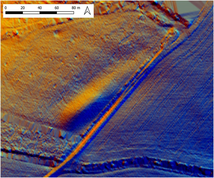
Figure 1: Multi-direction hillshade of LiDAR 1m DTM showing the Warren Farm long barrow. Contains public sector information licensed under the Open Government Licence v3.0.
Unfortunately, there was one niggling problem that tempered any initial confidence – the significant length of the resultant mound, measured from the LiDAR plot at a huge 135m. This was significantly longer than any recorded barrow in Hampshire, and indeed across Southern England, if the special class of bank barrows is excluded. More evidence would therefore be required to resolve this conundrum.
Incredibly, this evidence has just turned up on Google Earth on their aerial imagery dated July 2025 (Figure 2 and Figure 3). This shows two sections of buried ditch flanking the mound. One is represented as a dark slightly curving mark to the north-west of the most substantial section of the remaining mound. However, crucially, there is also a very clear, slightly curving cropmark of a buried ditch to the south-east of the ‘ridge’. This ditch is parallel to the edge of the suspected tail of the long barrow, and there is a very clear rounded terminal to the ditch, typical of a long barrow ditch cropmark.
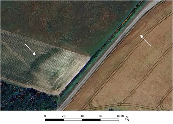
Figure 2: Google Earth aerial imagery showing cropmarks of two sections of buried ditch flanking the long barrow. ©Google and Airbus 2025.
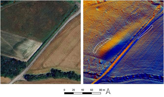
Figure 3: Trace of cropmarks overlaid onto LiDAR plot. Contains public sector information licensed under the Open Government Licence v3.0. ©Google and Airbus 2025.
The cropmarks appear to confirm initial suspicions that this long barrow is much longer than originally recorded. There are of course some aspects that need to be confirmed. There are no cropmarks flanking the central section of the long barrow, and so in theory this could be two long barrows aligned end-on-end. As a counterpoint to this theory, the LiDAR (Figure 1) indicates a continuous earthwork extending from a more bulbous south-west end, suggesting possible extension of an original shorter long barrow.
If this long barrow really is 135m long, how does this compare with other Hampshire long barrows? The chart in Figure 4 shows the lengths of all known long barrows in Hampshire, and it can be seen that the length of the example at Warren Farm far surpasses any other long barrow in Hampshire, by some 25m. Some of the longest surviving examples are included as LiDAR plots in Figure 5, allowing a comparison of not just the size but also the shape of the mounds. That at East Martin has also been denuded due to ploughing, but can be seen to be of similar scale and shape to that at Warren Farm, with a slightly tapering mound. The East Martin example was only fairly recently identified and surveyed by members of Avon Valley Archaeological Society (AVAS) (Gill 2018). For the other two examples shown in Figure 5, the Warren Farm mound can be seen to be far more substantial in size, particularly with respect to Knap Barrow. The latter example is also far more regular in shape, even taking into account the plough damage to Warren Farm long barrow.
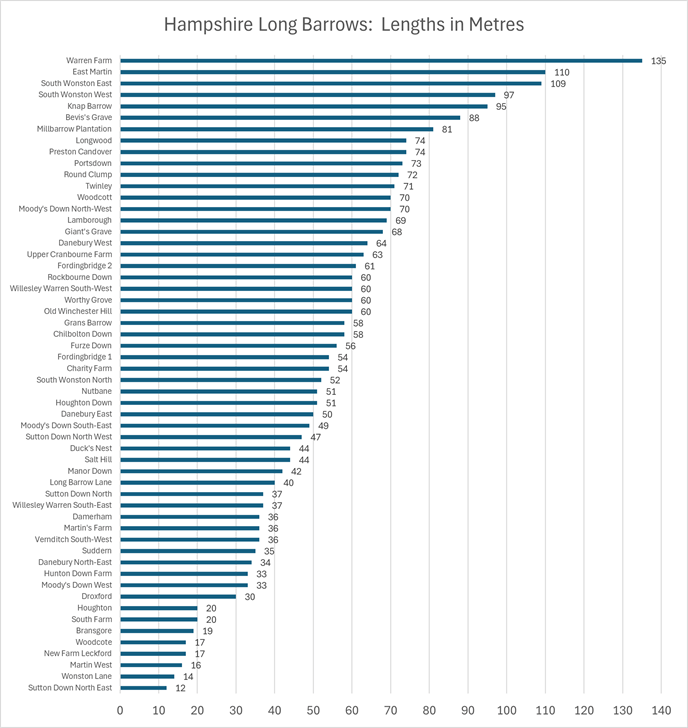
Figure 4: Comparison of the lengths of long barrows in Hampshire
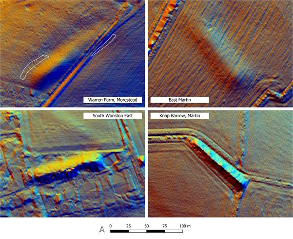
Figure 5: Comparison of Warren Farm with other extant Hampshire long barrows of substantial length. Contains public sector information licensed under the Open Government Licence v3.0.
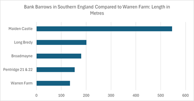
Figure 6: Comparison of the length of Warren Farm long barrow with bank barrows in Dorset
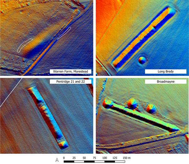
Figure 7: Comparison of Warren Farm long barrow with bank barrows in Dorset. Contains public sector information licensed under the Open Government Licence v3.0.
It was mentioned above that bank barrows have been identified as another class of exceptionally long mound. Given the length of the Warren Farm example, it merits comparison with other bank barrows. Hampshire is lacking any known bank barrows, but we can look to the neighbouring county of Dorset for examples. Figure 6 shows that Warren Farm is shorter than key examples in Dorset. An appreciation of the shape and form of bank barrows can be gained from Figure 7. One interesting feature of the Pentridge 21 and 22 example is the extension of a standard long barrow with a ‘tail’, and Bradley (1983: 15) suggests these two long barrows should be considered together as a bank barrow. This ‘extension’ seems to have parallels with the possible extension of the Warren Farm long barrow, as discussed above. Indeed the Long Bredy bank barrow, also shown in Figure 7, also has hints of extension, perhaps starting out as a central long barrow that was extended in each direction (McOmish & Tuck 2000: 21–23)
However, Bradley (1983: 15) defines a bank barrow not only by its exceptional length, but also its form, indicating they are ‘extremely long parallel-sided’ mounds. The three Dorset examples in Figure 7 all have very straight parallel sides, and this is a distinguishing feature from that at Warren Farm, which, has a more tapering form, with slightly curving sections of ditch revealed by the cropmarks. It would therefore be difficult to assign the Warren Farm long barrow to the bank barrow class, and it seems it is rather a very lengthy long barrow.
One further question is why such a large monument is located where it is. All of the other substantial long barrows and bank barrows are positioned in areas rich in Neolithic and later Bronze Age monuments, acting as important ceremonial landscapes that attracted activity for significant periods of time. In contrast, the area south-east of Winchester is hardly renowned for its Neolithic monuments, with a scattering of long barrows and later Bronze Age barrows. The Warren Farm long barrow stands at the north-west edge of a sparse scatter of long barrows east of the Itchen Valley (Figure 8).
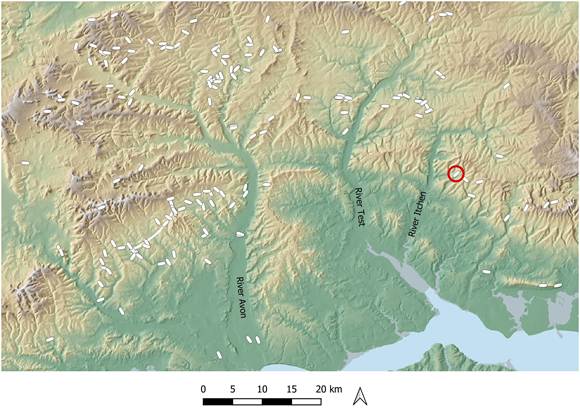
Figure 8: Distribution of long barrows in central Southern England, with the Warren Farm long barrow circled. Contains public sector information licensed under the Open Government Licence v3.0.
Overall, the LiDAR and cropmark evidence suggests that we may be justified in claiming the Warren Farm long barrow is indeed the longest long barrow in Hampshire. It is hoped, with landowner permission, that we may be able to undertake a geophysics survey to clarify the sections of ditch that have yet to be revealed through cropmarks. It might be that the Warren Farm long barrow is an outlier in terms of its size, but the wider area would repay more detailed investigation in case other similar monuments have been overlooked.
References
Bradley, R. 1983. The bank barrows and related monuments of Dorset in the light of recent fieldwork. Proceedings of the Dorset Natural History & Archaeological Society 105: 15–20.
Gill, M. 2018. Geophysics Survey at Bustard Farm, East Martin (AVAS Reports AVAS2018-01). Unpublished. https://avonvalleyarchsoc.files.wordpress.com/2023/01/avas-geophysics-survey-bustard-farm-east-martin-final.pdf.
McOmish, D. & C. Tuck. 2000. Long Bredy Bank Barrow, Long Bredy, Dorset. PDF. AI/14/2000 (Archaeological Investigation Report Series). English Heritage. http://archaeologydataservice.ac.uk/archives/view/greylit/details.cfm?id=62610. https://doi.org/10.5284/1056487.
RCHME. 1979. Long barrows in Hampshire and the Isle of Wight. London: H.M. Stationery Off.
Downloadable PDF of this article:

Brilliant article. Hampshire’s LBs are overdue a re-analysis. Smith and co.’s RCHME book is nevertheless a great summary.
LikeLike