
by Michael Gill
This article can be accessed / cited here: https://doi.org/10.5281/zenodo.17265581 and is available for download as a PDF at the end of this article.
Even though Neolithic long barrows are relatively rare, particularly in comparison to Bronze Age round barrows, new discoveries are on occasion made. It is often a specific combination of weather conditions and type of crop that can lead to clear cropmarks appearing for a short period of time, and this was the situation in 2025, when distinct cropmarks over wide areas were revealed in satellite imagery. Such cropmarks in the parish of Owlesbury near Winchester revealed a previously unrecorded long barrow, just 300m from another long barrow.
The cropmarks of this unrecorded long barrow are 1.2km east south-east of Morestead, a village about 5km south-east of Winchester in Hampshire. The cropmarks (Figure 1), which I spotted recently on Google Earth, clearly show the characteristic flanking ditches of a long barrow, which run almost parallel but taper slightly, with the wider end towards the south-east.
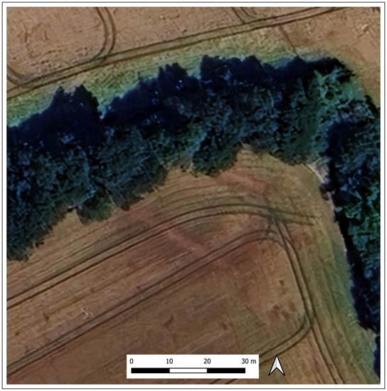
Figure 1: Google Earth imagery showing cropmarks of the buried flanking ditches of the long barrow. ©Google and Airbus 2025.
The long barrow is at the edge of a field and so its full extent is not revealed, with the cropmarks disappearing under thick tree cover. The part of the barrow that is visible is about 30 metres in length and is likely to have been originally between 35 and 45 metres in length. There is no cropmark evidence for it continuing into the adjacent field. Its grid reference is SU 52167 25077. It is located close to the track called Honeyman Lane and so will be called the ‘Honeyman Lane’ long barrow for the rest of this article.
The LiDAR Digital Terrain Model (DTM) suggests traces of a ploughed-out mound in the area of the cropmarks. Figure 2 shows a hillshade representation of the 1m DTM, using a high degree of vertical exaggeration (x7). There is a clear ‘bulge’ in the corner of the field that corresponds with the cropmarks.
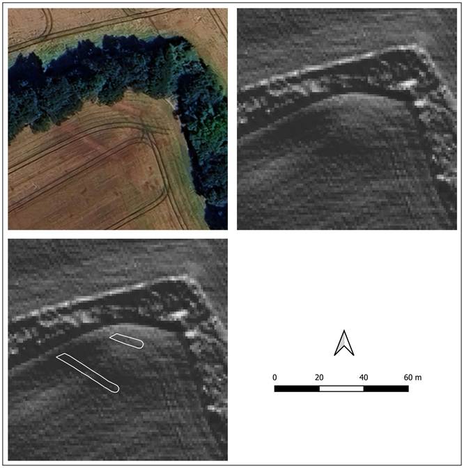
Figure 2: Plot showing how the cropmarks of the long barrow ditches relate to the LiDAR 1m DTM. Contains public sector information licensed under the Open Government Licence v3.0. ©Google and Airbus 2025.
It is interesting to consider the landscape positioning of the long Barrow. It is just 300m south south-east of the Warren Farm long barrow (Figure 2), a barrow that recent cropmark evidence suggests may be a massive 135 metres in length, making it the longest long barrow in Hampshire, and indeed one of the longest in southern England (Gill 2025). This monument stands at the north-west edge of a sparse scatter of long barrows east of the Itchen Vally, and could be considered an outlier, given that other long barrows of considerable size often occur in denser concentrations of monuments.
It is therefore significant that another long barrow has now been discovered in close proximity to the Warren Farm monument, providing evidence for increased Neolithic funerary activity in the immediate area. While the Warren Farm example has a prominent position on a ridge between two valleys, the Honeyman Lane barrow is more hidden in the valley below (see Figure 3). Analysis of the LiDAR profile between the two barrows suggests there is no visual relationship between the monuments. It is also slightly unusual that, unlike most long barrows, the Honeyman Lane Long Barrow is not aligned with the contours along the valley side.
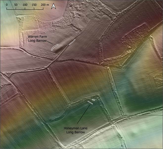
Figure 3: LiDAR plot showing the proximity of the Warren Farm Long Barrow to the Honeyman Lane Long Barrow. Contains public sector information licensed under the Open Government Licence v3.0. ©Google and Airbus 2025.
It is also useful to take a slightly wider view, to incorporate another nearby long barrow, the Longwood long barrow. As shown in Figure 4, this long barrow is positioned on a ridge on the other side of the valley, some 1.4km to the south-east of the Honeyman Lane example. Similar to the Warren Farm barrow, it is of considerable length, some 76 metres, and still possesses a mound of substantial volume, rising 2 metres above its levelled ditches (RCHME 1979: 46).
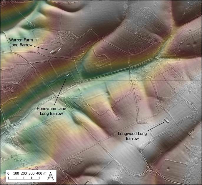
Figure 4: LiDAR plot showing the position of the long barrows in the vicinity of the Honeyman Lane Long Barrow. Contains public sector information licensed under the Open Government Licence v3.0. ©Google and Airbus 2025.
The size and shape of the Warren Farm, Longwood and Honeyman Lane long barrows are compared in Figure 5. It is clear they are very different in character, The latter was probably much smaller in comparison to the others, even allowing for the part which is obscured. The Warren Farm example is much longer that that at Longwood, although the Lidar suggests that the former may have been extended by adding a tail to the north-east. The Warren Farm mound has a very different orientation to the other monuments. It is clear that there was no local ‘template’ for the construction of long barrows in this area, and this pattern of contrasting monument forms in local clusters is in fact quite common (RCHME 1979: xxv).
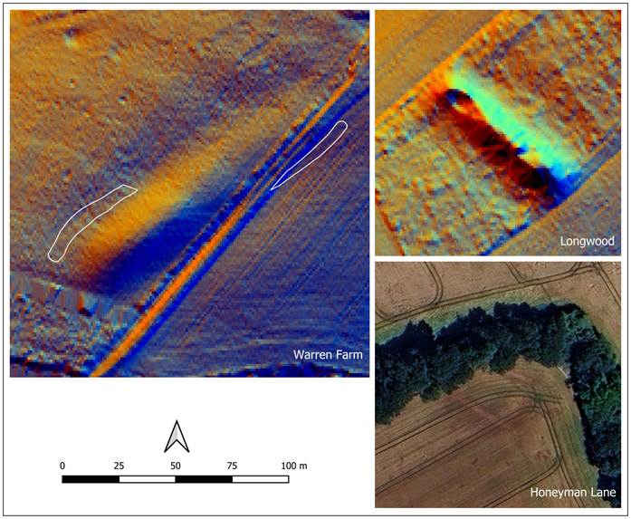
Figure 5: Comparison of the Warren Farm, Longwood and Honeyman Lane long barrows, all shown at the same scale. Contains public sector information licensed under the Open Government Licence v3.0. ©Google and Airbus 2025.
Despite the contrasting monument forms, it is clear that the valley that hosted the barrows was significant in the Neolithic period. This importance is elevated by the substantial size of two of the monuments, and the discovery of a third long barrow in the valley indicates a distinct cluster in a wider sparse scatter of long barrows.
A wider context for these long barrows is shown in Figure 6. It can be seen that the valley they cluster around is south-west trending and leads to the Itchen Valley. It may be that the valley provided a convenient routeway for Neolithic people from the lower ground around the Solent to the high ground that is bracketed by the Itchen and Meon valleys.
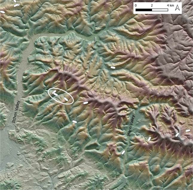
Figure 6: Map showing the wider distribution of long barrows near Morestead. The Warren Farm, Honeyman Lane and Longwood long barrows are circled. Contains public sector information licensed under the Open Government Licence v3.0. ©Google and Airbus 2025.
Given the relatively sparse concentration of long barrows in this part of Hampshire, any long barrow discovery is significant and adds to our understanding of the Neolithic activity in the area. The importance of the Honeyman Lane long barrow is elevated by its location between two long barrows of substantial size, indicating a cluster of Neolithic activity previously not subject to any significant landscape research. The discovery of the Honeyman Lane long barrow also shows that our understanding of the distribution of long barrows is still evolving, and it might be that areas less well known for their Neolithic activity could benefit from closer reconnaissance for monuments that may be awaiting discovery.
References
Gill, M. 2025. Unrecognised as the longest long barrow in Hampshire? The Warren Farm long barrow at Morestead. Zenodo. https://zenodo.org/doi/10.5281/zenodo.16921974. https://doi.org/10.5281/ZENODO.16921974.
RCHME. 1979. Long barrows in Hampshire and the Isle of Wight. London: H.M. Stationery Off.
Downloadable PDF of this article:
