
by Michael Gill
This article can be accessed / cited here: https://doi.org/10.5281/zenodo.17643705 and is available for download as a PDF at the end of this article.
The rolling chalkland of Cranborne Chase has a rich variety of Neolithic monuments, including a dense concentration of long barrows clustering near the Dorset Cursus. This region has long attracted the attention of antiquaries and archaeologists, and as a result is one of the most closely studied prehistoric landscapes in Britain. Consequently, it could be assumed that the most significant Neolithic monuments have already been located and studied. This, however, is far from the truth, with, for example, a number of long barrows and a long enclosure being revealed by aerial imagery and geophysical survey in recent years (Gill 2018, 2023; Gill & Field 2019). One of these long barrows has been shown to be an amazing 112 metres long, and despite being ploughed out, still possesses a spread mound of considerable bulk. The intensification of farming on the downs of Cranborne Chase inevitably led to the destruction of many earthwork monuments, and a careful review of historic maps, LiDAR, and aerial imagery can still lead to new discoveries. This is the case with a probable long barrow at Whitsbury, the mound of which was destroyed in the 19th Century. Since then, it has been hiding in plain sight, potentially being mis-interpreted and recorded as the site of a round barrow.
This site is 700 metres north north-west of Whitsbury, a small Hampshire village near Fordingbridge that is notably dominated by a bivallate hillfort. The barrow mound is shown on the first edition Old Series one-inch Ordnance Survey map surveyed between 1797 and 1809 and published in 1811, as shown in Figure 1.
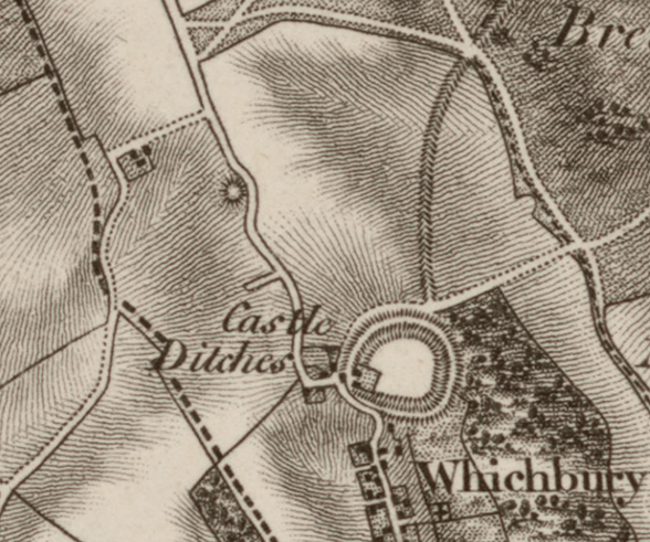
Figure 1: Ordnance Survey 1-inch Old Series map, surveyed 1797-1809, published 1811. The barrow mound is depicted to the north-west of the hillfort, with the road bending around it.
There are a number of pertinent factors in the depiction of the barrow. The first is the fact that only substantial barrows, key landscape features, are shown on the first edition one-inch map because of its relatively small scale. The fact the road is shown deviating around the mound supports the assumption that the barrow was of significant size, large enough to provide a sufficient obstacle for the road to pass around it.
A review of the depiction of other known long barrows on the one-inch map suggests they are not always shown with an accurate shape, with mound shapes ranging from oval to circular. For example, Gran’s Barrow between Rockbourne and Martin, and a nearby example on Little Toyd Down are both depicted with circular mound symbols. It is also the case that many of the barrows that were chosen for depiction on this edition of the Ordnance Survey one-inch map are long barrows, probably due to them being of greater size and therefore more notable topographic features compared to the much more numerous Bronze Age round barrows that existed on Cranborne Chase. Could it be that the example at Whitsbury is also a long barrow?
Unfortunately, a review of the subsequent Ordnance Survey maps suggests that the barrow mound was later flattened. It is missing from the 1880 one-inch map, but the road still has a kink at this location. On the six-inch Ordnance Survey map surveyed in 1871, published in 1872, the destroyed mound is indicated by the label ‘Tumulus (Site of)’, as shown in Figure 2.
Figure 2: Ordnance Survey 6-inch map, surveyed 1871, published 1872. The location of the destroyed barrow is indicated by the map label “Tumulus (Site of)”.
The barrow is recorded as ‘a possible round barrow’ in the Historic England Research record entitled ‘Whitsbury 9’ with a description as follows:
“(SU12212027) Tumulus (O.E) (site of). (1). Ploughed out barrow. (2). No trace of this barrow remains. (3). SU 12222028. Mound, possible barrow on the ridge north of Whitsbury Hill. Just discernible at point marked ‘site of Tumulus’ on OS maps. A second probable barrow lies 20m to the S [SU 12 SW 83]. The first edition of the OS 1-inch map (1811) shows a single barrow with the road making what appears to be an unnecessarily wide sweep round it.” (Historic England 2025)
Despite the barrow being sufficiently flattened for it to be removed from the Ordnance Survey map as a topographic feature, LiDAR data released by the Environment Agency a few years ago suggests that traces of the mound still survive. Figure 3 shows a multi-direction hillshade of the LiDAR 1m Digital Terrain Model (DTM), with a subtle elongated rise being present at the point indicated on the Ordnance Survey maps, with the modern road still deviating around this point. The remnant mound is about 44m in length and truncated by the road along its eastern edge. It hints at a linear rather than round mound, although the significant erosion of the mound means other evidence would be required to confirm its original form.
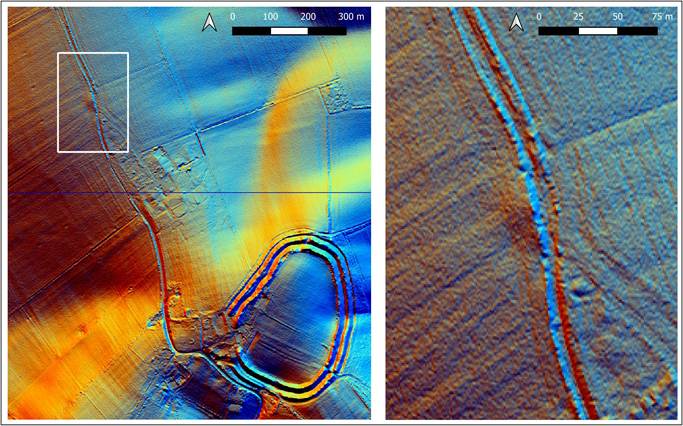
Figure 3: Multi-direction hillshade of LiDAR 1m DTM showing traces of the barrow mound where the modern road deviates. Contains public sector information licensed under the Open Government Licence v3.0.
Subsequent to the release of the LiDAR data, publicly available aerial imagery was monitored by the author for cropmark evidence. No clear-cut cropmark evidence of the flanking ditches was forthcoming, possibly because of the field edge location, with cultivation marks masking any potential cropmarks. One Google Earth image from 2005 shows a light linear mark flanked by a darker mark but is too ephemeral to provide any compelling evidence.
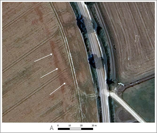
Figure 4: Possible cropmark of the western flanking ditch of the long barrow, as shown on Google Earth imagery. ©Google and Airbus 2025.
However, imagery from the drought of 2025 has recently been uploaded to Google Earth and has provided significant cropmark evidence for a number of long barrows – see for example (Gill 2025a; b). This includes the destroyed barrow at Whitsbury as shown in Figure 4. Incredibly, for the first time, a cropmark is shown that suggests the presence of a long linear buried ditch running parallel to the mound, indicated by arrows in Figure 4. This mark is slightly curved and is about 44m in length and 5m in width. A trace of the cropmark has been overlaid on the LiDAR hillshade in Figure 5C, showing that the cropmark perfectly flanks the almost destroyed barrow mound. Figure 5A and B include the Google Earth imagery for 2005 and 2025 respectively, shown at the same scale and extent as the LiDAR image.
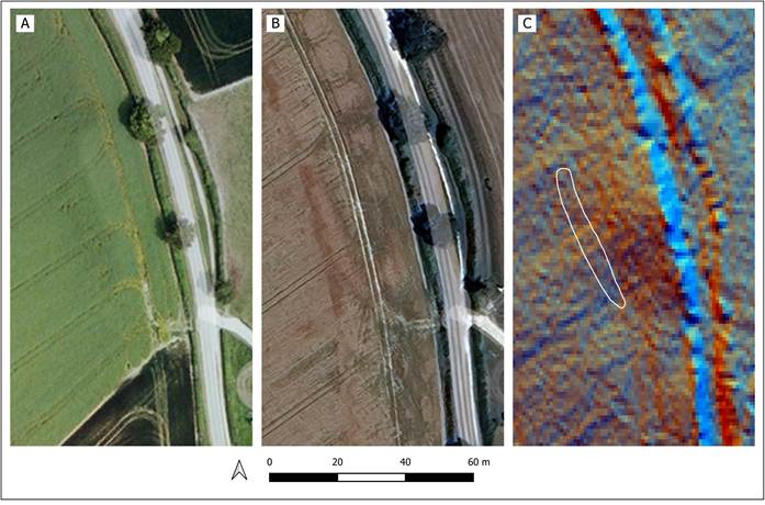
Figure 5: Comparison of the position of cropmarks and the traces of the mound as shown in LiDAR. A: Google Earth 2005 imagery. B: Google Earth 2025 imagery. C: Hillshade of the LiDAR 1m DTM. Contains public sector information licensed under the Open Government Licence v3.0. ©Google and Airbus 2025
This cropmark evidence appears to show the presence of a buried flanking ditch of the barrow and therefore suggests that this was indeed a long barrow rather than a round barrow. This is further supported by the landscape position of the barrow, which sits on top of one of the ridges between the valleys that trend south south-east towards the Avon Valley, as shown in Figure 6. The nearby long barrows of Duck’s Nest and Grand Barrow to the west have almost identical locations, aligned along similar ridges. The barrow at Whitsbury in fact fills in a gap in what is otherwise a fairly regularly spaced distribution of barrows around the upper reaches of these chalk valleys. It may be that these barrows were prominently positioned on routeways along the edges of the valleys that provided points of access onto the chalk downs from the river valley to the south-east.
It is often the case that one form of evidence, be it old maps, aerial photographs or LiDAR data, can lead to insecure conclusions about the form and nature of destroyed or eroded prehistoric monuments. In this case, several strands of evidence combine to suggest that a long barrow has been mis-identified as a round barrow. There can be no doubt that a large mound existed in the early nineteenth century, a mound substantial enough for it to be shown on the one-inch map and for a road to be shown deviating around it. Many of the barrows marked on the one-inch map in this region were long barrows, mainly due to their significant size when compared to other round barrows, and some were marked with oval or even round earthwork symbols, showing that the symbol for a barrow was sometimes stylised rather than providing an accurate depiction of the true form of the mound. Despite the barrow being destroyed and omitted from later maps, the LiDAR data still shows subtle traces of an elongated remnant mound, exactly at the point where the modern road still slightly deviates, fossilising the presence of a now destroyed feature. Together, the evidence from the historic maps and the LiDAR data is insufficient to reliably identify the original form of the mound, simply providing clues to the possible presence of a long barrow. However, cropmark evidence from the drought of 2025 has finally provided supporting evidence of a buried ditch flanking the mound, and together with the map and LiDAR evidence, and the typical landscape position, combines to provide compelling evidence that the barrow depicted on the 19th century Ordnance Survey Map was indeed a long barrow.
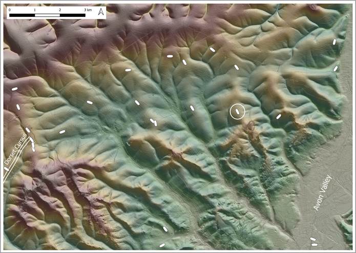
Figure 6: The distribution of long barrows on Cranborne Chase in the vicinity of Whitsbury. The Whitsbury long barrow that is the subject of this article is circled. Contains public sector information licensed under the Open Government Licence v3.0.
References
Gill, M. 2018. Geophysics Survey at Bustard Farm, East Martin (AVAS Reports AVAS2018-01). Unpublished. https://avonvalleyarchsoc.files.wordpress.com/2023/01/avas-geophysics-survey-bustard-farm-east-martin-final.pdf.
—. 2023. Geophysics Survey of Three Long Barrows and a Long Mortuary Enclosure near the Dorset Cursus (AVAS Reports AVAS2023-02). Unpublished. https://avonvalleyarchsoc.files.wordpress.com/2023/02/avas-geophysics-survey-long-barrows-and-long-mortuary-enclosure-near-dorset-cursus-v1_0.pdf.
—. 2025a. Unrecognised as the longest long barrow in Hampshire? The Warren Farm long barrow at Morestead. Zenodo. https://zenodo.org/doi/10.5281/zenodo.16921974. https://doi.org/10.5281/ZENODO.16921974.
—. 2025b. An Unrecorded Long Barrow near Morestead, Hampshire. Zenodo. https://zenodo.org/doi/10.5281/zenodo.17265580. https://doi.org/10.5281/ZENODO.17265580.
Gill, M. & D. Field. 2019. New long barrow discoveries in the vicinity of the middle Avon valley and Cranborne Chase. PAST 91: 5–7. https://www.prehistoricsociety.org/sites/prehistoricsociety.org/files/publications/past/past91.pdf.
Historic England. 2025. Whitsbury 9 (Hob Uid 218076). Historic England Research Record. https://www.heritagegateway.org.uk/Gateway/Results_Single.aspx?uid=b97143fd-cc15-4ea0-9a0c-c72d74d79334&resourceID=19191.
Downloadable PDF of this article:
