
by Michael Gill
This article can be accessed / cited here: https://doi.org/10.5281/zenodo.19005909 and is available for download as a PDF at the end of this article.
The Candover Valley, a few kilometres south of Basingstoke, has long been recognised for its prehistoric remains and potential for further discoveries (Shore 1893). At Preston Candover, this is attested by the presence of a much denuded Neolithic long barrow (RCHME 1979: 14–15), numerous ring ditch cropmarks and a significant scatter of flint artefacts at Budd’s Hill (Williams-Freeman: 357–58). This article discusses three possible unrecorded long barrows located close to the latter site, revealed through analysis of publicly available aerial imagery.
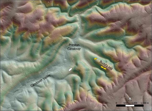
Figure 1: Location of the three possible long barrows near Preston Candover, shown in yellow. Existing recorded long barrow shown in white. Contains public sector information licensed under the Open Government Licence v3.0.
The three sites are shown in yellow in Figure 1. They are about 1.5km south-east of the village of Preston Candover, on the slope of Budd’s Hill. The existing recorded long barrow at Preston Candover is shown in white and is 1.5km to the west of the sites under discussion.
Zooming in to the area of Budd’s Hill, Figure 2 shows a more detailed location map of the three sites of interest. It is of note that a significant area of worked flint was found on top of the hill, reported by Ellaway and Willis. Among other finds, ‘several celts, part of a polished axe, a well worn fabricator, a leaf arrowhead, many scrapers, and various worked flints of uncertain use’ were found (Williams-Freeman: 357). According to the Historic England Research Record, this concentration is centred at the location shown in Figure 2.
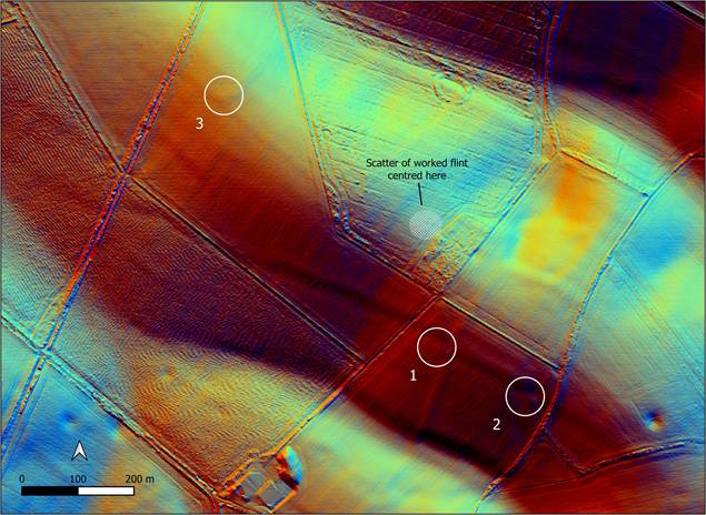
Figure 2: Location of the three possible long barrows, plus an indication of the location of scattered flint tools discovered by field walking. Contains public sector information licensed under the Open Government Licence v3.0.
The first two of the possible long barrows, marked 1 and 2 in Figure 2, are show in a series of aerial images shown in Figure 3, Figure 4 and Figure 5. The cropmarks are clearest in Figure 3, each represented by a white chalky soil mark, with what appears to be a flanking ditch cropmark to the south-west of each chalk soil mark. Some form of linear ditch crosses the field and passes alongside the north-east edge of each possible barrow, obscuring any clear evidence of a flanking ditch on this side, although the linear ditch does appear to widen slightly adjacent to each chalky area, hinting at the presence of a flanking ditch.
The westerly of the pair (site 1) is about 32m in length and is shown in more detail in Figure 6 and Figure 7. The eastern example is slightly smaller, about 27m in length and is shown in more detail in Figure 8. It is also worth noting that the available Lidar data suggests there is the remnant of a slight mound in the area of each chalk soil mark (Figure 9).
It is useful to review the evidence for and against these soil and cropmarks representing long barrows. The sites occupy a slightly unusual topographical position, on the slope of Budd’s Hill but not quite high enough to occupy a false crest location, often favoured by the builders of long barrows. When I first noticed these marks, the first impression was that they were more modern features, perhaps representing some form of construction related to agriculture, with the linear marks perhaps being of a similar age. It is also unusual that the marks at both sites are so similar, each being cut by similar linear features at similar positions, again suggesting a more modern origin.
Conversely, there are traits that suggest these marks could indeed be Neolithic long barrows. One clue is provided by a linear ditch that crosses site 1 obliquely from south south-west to north north-east. This linear cuts through the chalk area, suggesting it is later than the chalk mark feature. As can be seen in Figure 10, this linear ditch travels south and appears to be related to, and therefore possibly contemporary with, a sub-rectangular enclosure to the south, which appears to be of some antiquity, possibly Iron Age. If this is the case, it would date the chalk mound to be earlier than the linear ditch and enclosure.
Other factors contributing to a long barrow interpretation include the apparent presence of slightly curving flanking ditches suggested by the cropmarks, plus the fact that the linear boundary skirting the north-east edges of the chalky mounds appears to bend round and respect the possible barrows, suggesting the linear boundary is later in date. Added to this, Budd’s Hill has already been identified as a significant findspot for Neolithic and other prehistoric flintwork, providing supporting evidence for Neolithic activity in the vicinity of the possible barrows.
It is not possible to confirm or discount these sites as long barrows using cropmark and circumstantial evidence alone. A key priority to aid identification of these marks should be the use of other non-invasive techniques, such as geophysical survey, to clarify the plan and relationship of the sub-surface features. A discussion with the landowner may also be productive in exploring any more recent explanation for the cropmarks.
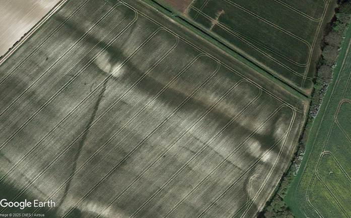
Figure 3: Google Earth imagery dated April 2017 showing two chalk soil marks with crop marks of ditches. ©Google.
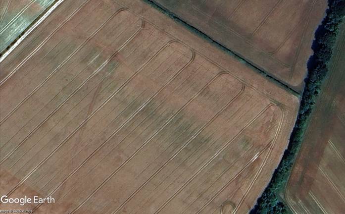
Figure 4: Google Earth imagery dated July 2025 showing crop marks of possible long barrows and other linear ditches. ©Google.
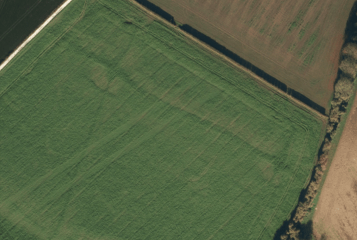
Figure 5: Aerial imagery shown on the OS Maps website,accessed February 2026.
 Figure 6: Detailed April 2017 Google Earth image of possible barrow 1. Figure 6: Detailed April 2017 Google Earth image of possible barrow 1. |  Figure 7: Detailed February 2026 OS Maps image of possible barrow 1. Figure 7: Detailed February 2026 OS Maps image of possible barrow 1. |
 Figure 8: Detailed April 2017 Google Earth image of possible barrow 2 Figure 8: Detailed April 2017 Google Earth image of possible barrow 2 |
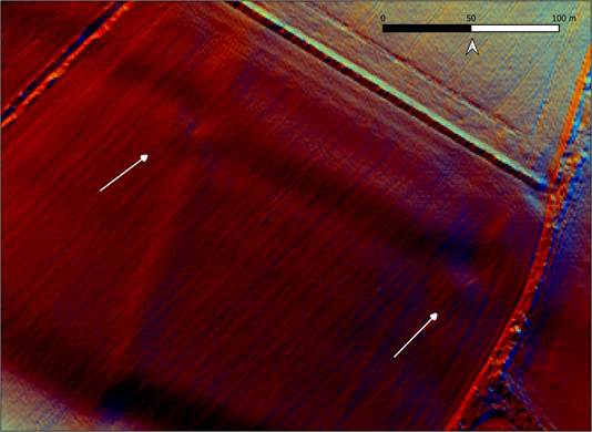
Figure 9: Locations of possible long barrows 1 and 2 shown on Lidar. Contains public sector information licensed under the Open Government Licence v3.0.
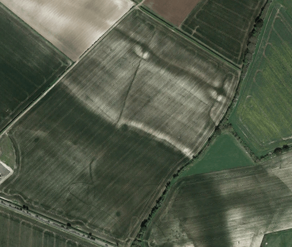
Figure 10: Wider aerial view showing the relationship of linear cropmarks to the possible barrows. Google Earth imagery dated April 2017. ©Google.
The location of the third possible long barrow (site 3) is about 600 metres to the north-west of sites 1 and 2, on the north-west flank of Budd’s Hill, as shown in Figure 2. At this point there is a slight mound shown in the Lidar data, and a clear U-shaped cropmark as shown in Figure 11, Figure 12 and Figure 13. This cropmark is about 17 metres in length, and 10 metres in width between the inner edges of the apparent ditches. These dimensions would place it at the extreme lower end of the normal size range for long barrows, but a combination of its prominent location, the apparent presence of an eroded mound, and its U-shaped nature mean that this feature should not be discounted as a member of the Neolithic family of linear mounded monuments exhibiting a diverse range of plan and size.
Long barrows with U-shaped ditches are known from Cranborne Chase and Dorset, dubbed the ‘Cranborne Chase type’, and it is now recognised that they were not restricted to that area (Grinsell 1959: 9; Barrett et al. 1991: 36). Ashbee (1984: 47) has noted that U-shaped ditches are often broken by causeways, which does not appear to be the case with this example at Preston Candover. Kinnes (1992: 65) suggests that the another characteristic of U-shaped ditch plans is that they open eastwards, but this is by no means a rule, with the well-preserved ‘Gussage St Michael 15’ example, located close to the Dorset Cursus, opening to the north-west.
Further evidence is required to establish with more certainty whether this U-shaped cropmark is of Neolithic origin. Again, the site would benefit from geophysical survey to clarify the plan of the apparent ditch.
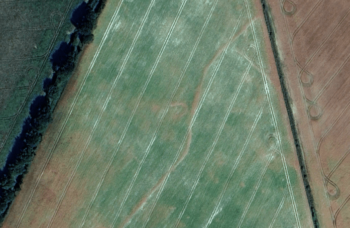
Figure 11: Overview of the cropmark of a possible long barrow at site 3. Google Earth imagery dated July 2025. ©Google.
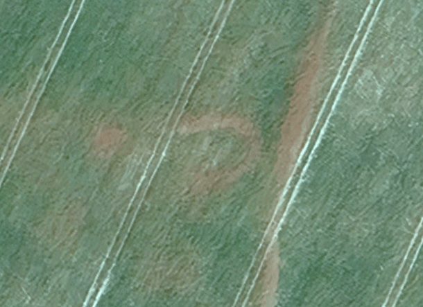
Figure 12: Detailed view of the cropmark at site 3. Google Earth imagery dated July 2025. ©Google.
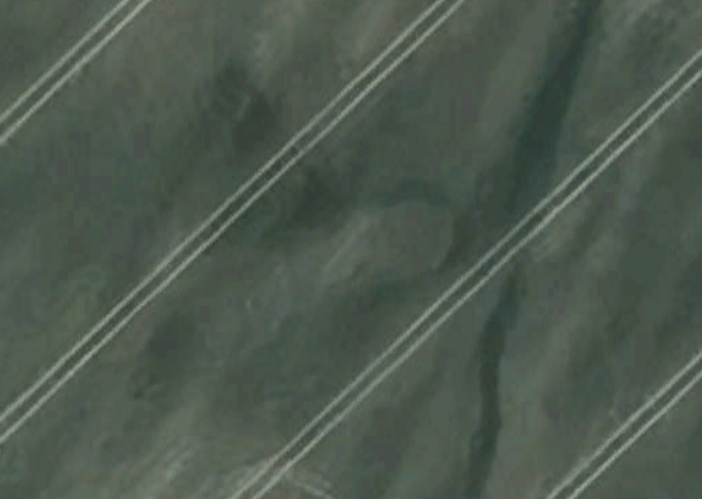
Figure 13: Detailed view of the cropmark at site 3. Google Earth imagery dated April 2022. ©Google.
Finally, it is instructive to compare the three possible long barrow sites near Budd’s Hill with the already recorded long barrow located south of the village of Preston Candover (Figure 1). A larger scale view of the location of the barrow is shown in Figure 14, and it can be seen that again, just like with the sites discussed above, it sits on the high ground above a dry valley that joins the main Candover valley. A good summary of the history of this barrow is provided in the RCHME (1979: 14–15) publication on long barrows in Hampshire and the Isle of Wight, describing how the barrow was almost destroyed by former quarrying. Indeed the local Reverend recounts how the mound ‘would have disappeared altogether but that the abundance of bones found induced the owner to leave off.’ (Wilson 1893: 117)
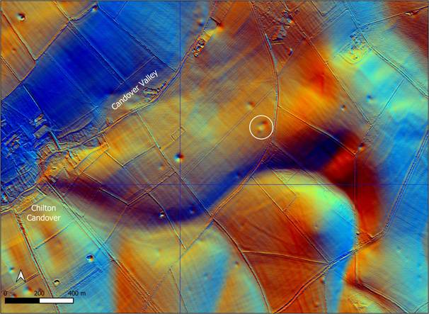
Figure 14: Location of the Preston Candover long barrow. Contains public sector information licensed under the Open Government Licence v3.0.
All that was left of the barrow after quarrying was an almost circular mound, causing scepticism among archaeologists in the first half of the 20th Century that the monument was actually a long barrow, as discussed by Hawkes (1940: 279–80). The shape of the current mound is shown in Figure 15 (C), and it can certainly be understood why there was a certain amount of uncertainty. However, cropmarks shown in publicly available imagery (Figure 15 A and B) clearly show long, slightly curving flanking ditches typical of a classic long barrow. The cropmark of the ditch to the north-west is more irregular in nature, exhibiting a discontinuity along the inner edge, with the distinct possibility that this represents a shorter ditch from an earlier phase, assuming it had not been caused by the later quarrying of the mound. There is a slight hint from the cropmarks that the opposing ditch shows a slight change in character and width at a similar position, strengthening this argument.
The published plan of the long barrow by RCHME is reproduced at the same scale as the Lidar and cropmarks in Figure 15 (D). It is clear that the ditch outlines shown on the plan, based on aerial photographs, are much straighter and more uniform that those shown in the cropmarks from Google Earth.
The cropmarks of the flanking ditches are 66m and 70m in length, and overall, this long barrow is a fairly sizeable example compared to the distribution of long barrow lengths in Hampshire, and much larger than the possible examples near Budd’s Hill.
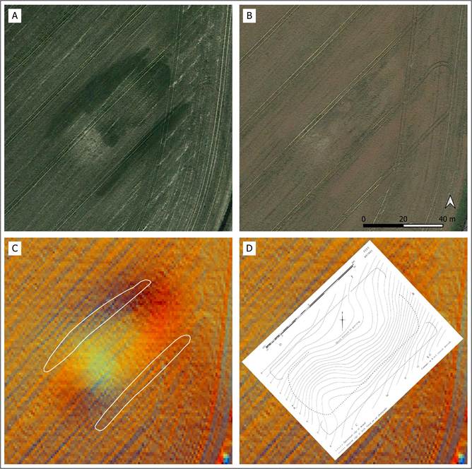
Figure 15: Comparison of cropmarks, Lidar and 1979 plan for the Preston Candover long barrow, all shown at the same scale. A: Google Earth 09/2018 ©Google. B: Google Earth 07/2020 ©Google. C: Lidar with cropmarks of ditches overlaid. D: RCHME (1979: fig. 29) plan of the barrow. Contains public sector information licensed under the Open Government Licence v3.0.
One other site near Preston Candover deserves mention, 1km south south-east of the Preston Candover long barrow. This is the most southerly of a pair of barrow mounds shown near the southern edge of Figure 14, halfway between the centre and the right edge of the figure. The mound looks circular, but aerial photographs suggest an oval shaped mound as shown in Figure 16. At first glance this could be identified as a possible long barrow, although caution is suggested by the lack of clear flanking ditches, with more of an encircling cropmark being present. The mound is recorded as a bowl barrow in the Hampshire HER (HER ID 19178), and the Historic England Research Record (Monument Number 239566) in fact suggests this is a ‘mutilated twin barrow, but insufficient remains to substantiate it’. The cropmark has a slight hint of a double component, suggesting a possible twin bowl barrow identification, although this site would certainly benefit from a geophysical survey to aid interpretation.
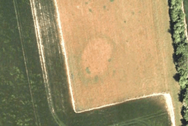
Figure 16: Aerial photograph of an oval shaped cropmark of a barrow 1km SSE of the Preston Candover long barrow. Google Earth imagery dated December 2005. ©Google.
In summary, there are a number of interesting cropmarks in the vicinity of the Preston Candover long barrow that would repay further investigation. Two similar eroded chalk mounds exist to the south of Budd’s Hill, each having similar orientations and relationships with linear features. They could have a modern explanation, but the fact they appear to be cut by what looks to be a possible prehistoric linear ditch suggests they would repay further investigation. Similarly, a small U-shaped ditch on the north-west flank of Budd’s Hill, associated with what appears to be a low ploughed out mound, suggests a possible Neolithic origin. The dense scatter of worked flint already recorded on Budd’s Hill demonstrates that this was an area of Neolithic activity that may yield further evidence and discoveries.
Finally, it is worth reviewing the location of the Preston Candover long barrow in the wider distribution of long barrows, as shown in Figure 17. It can be seen that this long barrow is somewhat of an outlier in the overall distribution, being on the edge of and fairly isolated from nearby clusters on the Hampshire Downs. To the north-east, no long barrows occur for a considerable distance with the exception of the Badshot long barrow near Farnham, itself a clear outlier. The Preston Candover long barrow sits near the head of a valley that eventually joins the River Itchen, and in this respect, has a similar location to the Lamborough long barrow near Cheriton, 12km directly south, which itself sits near springs that feed a tributary of the Itchen.
Given the Preston Candover long barrow is a relative outlier, a key research objective should be to investigate the possible long barrow sites nearby, as if confirmed, their presence could transform the distribution map and reveal a hitherto unrecognised concentration of Neolithic monuments in this part of Hampshire.
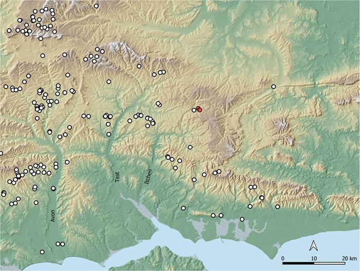
Figure 17: Map showing the distribution of long barrows in the region surrounding Preston Candover. Possible long barrow sites discussed in this article are shown in red. Contains public sector information licensed under the Open Government Licence v3.0.
References
Ashbee, P. 1984. The earthen long barrow in Britain. 2nd ed. Norwich: Geo Books.
Barrett, J.C., R. Bradley & M. Green (ed.). 1991. Landscape, monuments and society: the prehistory of Cranborne Chase. Cambridge: Cambridge University Press.
Grinsell, L.V. 1959. Dorset barrows. Dorchester: Dorset Natural History and Archaeological Society.
Hawkes, C.F.C. 1940. A Saxon spear-head and scramasax from the disputed long barrow at Preston Candover, Hants. Antiquaries Journal 20: 279–80.
Kinnes, I.A. 1992. Non-megalithic long barrows and allied structures in the British Neolithic (Occasional Paper / British Museum 52). London: Department of Prehistoric and Romano-British Antiquities.
RCHME. 1979. Long barrows in Hampshire and the Isle of Wight. London: H.M. Stationery Off.
Shore, T.W. 1893. The Candover Valley and its Prehistoric Inhabitants. Proceedings of the Hampshire Field Club & Archaeological Society 2 Part 3: 283–94.
Williams-Freeman, J.P. Field Archaeological Section: Report for 1918-1919. Proceedings of the Hampshire Field Club & Archaeological Society 8 Part 3: 352–58.
Wilson, S. 1893. Preston Candover. Hampshire Notes and Queries VII: 116–25.
Downloadable PDF of this article:
