
by Michael Gill
This article can be accessed / cited here: https://doi.org/10.5281/zenodo.19519637 and is available for download as a PDF at the end of this article.
Neolithic long barrows are amongst the earliest monuments in Britain and are relatively rare compared to the almost ubiquitous Bronze Age round barrow. Despite their rarity, the volume and frequency of new releases of aerial and satellite imagery on publicly available websites means that new discoveries of long barrows are sometimes made. This is the case with an example near East Meon, in Hampshire, where the cropmarks of a long barrow have recently been identified by the author. This article will describe the characteristics of the long barrow and its landscape position.
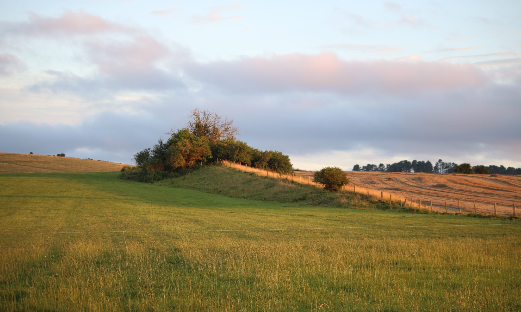
The location of the long barrow is shown in Figure 1. It is positioned on a gentle west facing slope, adjacent to the springs that represent the source of the River Meon. It is about 1.3 km south of the village of East Meon.
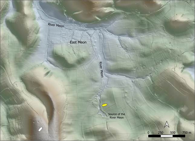
Figure 1: Map showing the location of the recently discovered long barrow, shown with a yellow symbol, near the source of the River Meon. The location of the nearby Salt Hill long barrow is shown with a white symbol. Contains public sector information licensed under the Open Government Licence v3.0.
Figure 2 shows a recent image of the cropmarks (from Google Earth 2025 imagery), representing the two buried flanking ditches of the long barrow, orientated almost east-west. They are tapered, with the wider end to the east. Each ditch is approximately 21 metres long. The gap between the ditches is about 17m at the east end and 12m at the west end. The cropmarks are centred at National Grid Reference SU 68561 20593. They were first noticed on 13th November 2022 by the author and subsequently reported to the Hampshire HER. They have been allocated an HER ID of 73199.
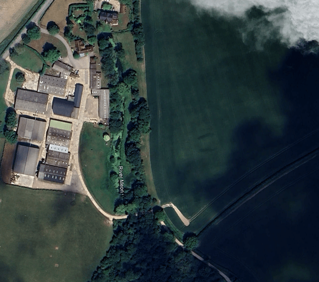
Figure 2: Aerial image showing the cropmarks of the flanking ditches of the recently discovered long barrow, just right of centre. Google Earth Imagery dated 30/06/2025 ©Google
The argument that these ditches are archaeological rather than agricultural in nature is bolstered by the fact the cropmarks appear on aerial images from different years, as show in Figure 3. In each case, cropmarks of very similar character are present.
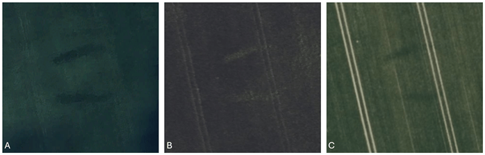
Figure 3: Cropmarks showing the flanking ditches of the long barrow, from different aerial images. A: Google Earth Imagery dated 30/06/2025 ©Google. B: Bing Maps imagery accessed 28/03/2026 ©Microsoft. C: Apple Maps imagery accessed 13/11/2022 ©Apple Maps.
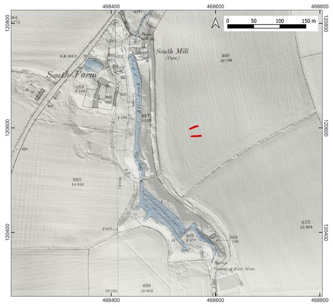
Figure 4: Ordnance Survey 6-inch map (revised 1895 and published 1896), draped over Lidar. The spring source of the River Meon is labelled. The location of the long barrow has been superimposed in red. Contains public sector information licensed under the Open Government Licence v3.0
The topographic location of the long barrow appears to be significant. As shown in Figure 4, it is just a short distance from the source of the River Meon, where a series of springs feed the river. In prehistoric times, it is likely that springs were seen as special, even magical places, where pure water, essential for life, inexplicably rushed forth from the ground (Field & McOmish 2016: 26). This importance is attested in other regions where a relationship between long barrows and springs and the sources of rivers and streams has been noted (Field 2006: 104).
As early as 1925, in his magisterial overview of the long barrows in the Cotswolds, Crawford (1925: 5–7) devoted several pages to the relationship between long barrows and water sources in the form of springs. At Upper and Lower Swell he notes ten long barrows within an area of two square miles, due to ‘the abundant perennial supply of water’ (Crawford 1925: 5) from the numerous springs that line the side of the valley; the region is still well known for its numerous strong springs. Crawford (1925: 7) cites a similar reason for the concentration of long barrows in the Avening region. Elsewhere, at the Giant’s Hill long barrows near Skendleby, Lincolnshire, ‘a strong spring rises at the bottom of the slope on which the barrow stands’ (Phillips 1936: 40), while close to the well-known West Kennett long barrow near Avebury, the Swallowhead Spring is recognised as a source of the River Kennet and is still venerated to this day as a symbolic and sacred spring (Cannon 2005: 203–7). A similar relationship is noted by Wymer (1965: 1–3) at Lambourn in Berkshire, where it is believed the long barrow was positioned close to a spring. The spring then retreated a short distance down the valley and was marked by the set of later Bronze Age barrows, know as the ‘Lambourn Seven Barrows’.
This pattern is repeated on Cranborne Chase, where a series of long barrows appears to mark the spring line of a number of streams that flow in a south-eastern direction towards the Avon and the Stour (Barrett et al. 1991: 54). Examples include Wor Barrow, which sits close to a spring that was later to attract a number of Bronze Age barrows at Oakley Down (Field 2006: 104). To the north-east, an important and remarkable water source at ‘Spring Pond’ near Rockbourne (Cunliffe 1985: 19–23), is watched over by the substantial ‘Duck’s Nest’ long barrow, with the long barrows of Gran’s Barrow and Knap barrow not far away. Spring Pond also attracted a series of Bronze Age round barrows, just as at Oakley Down.
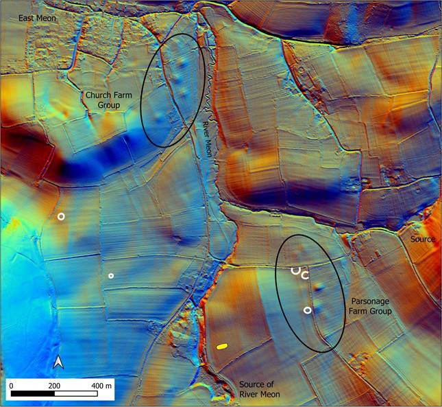
Figure 5: Lidar map showing the location round barrows and ring ditches near the East Meon long barrow. Cropmarks of ring ditches are shown in white. Contains public sector information licensed under the Open Government Licence v3.0.
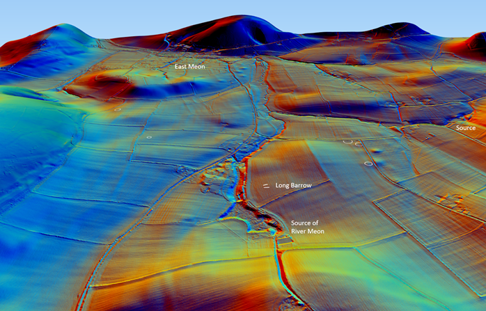
Figure 6: 3D view of the topographic location of the long barrow at the source of the River Meon. Contains public sector information licensed under the Open Government Licence v3.0.
Returning to the long barrow at the source of the Meon, the barrow itself did not directly attract later Bronze Age funerary monuments, but taking a slightly wider view, significant concentrations of apparent Bronze Age barrows are located not far away, underlining the importance of the river and its spring sources in prehistoric times. These probable Bronze Age barrows were noted in a comprehensive and valuable survey of barrows in the Petersfield area, and were named the Church Farm Group, adjacent to the River Meon near East Meon, and the Parsonage Farm Group, located between the recognised source of the Meon and the spring source of a small tributary (Needham & Anelay 2021: 546–47). These are shown in Figure 5, which also shows the locations of ring ditches revealed by aerial imagery. Figure 6 provides a 3D view of the same area.
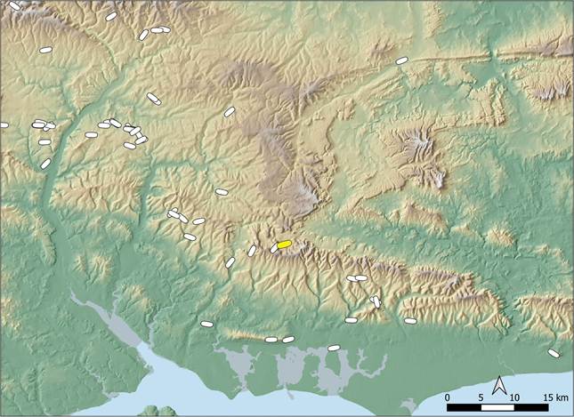
Figure 7: Distribution of long barrows in the region of East Meon. The East Meon long barrow is shown with a yellow symbol. Contains public sector information licensed under the Open Government Licence v3.0.
Taking a wider view, it can be seen in Figure 7 that the long barrow near East Meon sits on the northern edge of a scatter of long barrows on the high chalk downs that trend from Hampshire in the west to Sussex in the east. The nearest long barrow is Salt Hill, just 1.4km to the west, which occupies a very different topographic location, high on a chalk ridge. There is not however a dense concentration of long barrows in this area of the Hampshire chalk, particularly in comparison to dense clusters of monuments further west, such as those that straddle the Test Valley near South Wonston and Danebury. The discovery of the long barrow at East Meon is therefore an important addition to our knowledge of the sparse scatter of Neolithic monuments in the area, and provides an interesting example of a topographic position near the source of a river that bears comparison with examples across southern England.
References
Barrett, J.C., R. Bradley & M. Green (ed.). 1991. Landscape, monuments and society: the prehistory of Cranborne Chase. Cambridge: Cambridge University Press.
Cannon, J. 2005. New myths at Swallowhead: the past and present in the landsacpe of the Marlborough Downs, in G.R. Brown, D. Field & D. McOmish (ed.) Avebury landscape: aspects of the field archaeology of the Marlborough Downs: 202–11. Oxford: Oxbow books.
Crawford, O.G.S. 1925. The Long Barrows of the Cotswolds. Gloucester: John Bellows.
Cunliffe, B. 1985. Heywood Sumner’s Wessex. Wimborne: Roy Gasson Associates.
Field, D. 2006. Earthen long barrows: the earliest monuments in the British isles. Stroud: Tempus.
Field, D. & D. McOmish. 2016. Neolithic horizons: monuments and changing communities in the Wessex landscape. Oxford: Fonthill.
Needham, S. & G. Anelay. 2021. Barrows at the core of Bronze Age communities: Petersfield Heath excavations 2014-18 in their regional context. Leiden: Sidestone Press.
Phillips, C.W. 1936. The Excavation of the Giants’ Hills Long Barrow, Skendleby, Lincolnshire. Archaeologia, 37–106.
Wymer, J. 1965. Excavation of the Lambourn Long Barrow, 1964. Berkshire Archaeological Journal 62: 1–16.
Downloadable PDF of this article:
